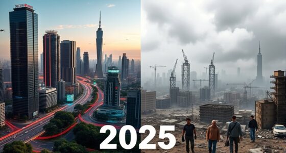
Somewhere in the near future, most cities will exist twice.
Once in concrete and glass — and once as a living data model, updated second by second from the sky and from a million sensors, that you can rewind like footage, simulate like a game, and question like an oracle. Not a map. Not a dashboard. A breathing replica of the real place, in which every vehicle has a history and the whole city can be asked, in plain language, what it is doing.
Urban planners already have a name for the static version of this: the digital twin. What turns that planning tool into something far larger — and far more double-edged — is the convergence of three technologies that all matured at once: persistent wide-area sensing like Wide-Area Motion Imagery (WAMI), all-weather radar to fill its blind spots, and frontier AI finally capable enough to make sense of the firehose. Put them together and you get a city that watches itself, remembers everything, and can answer almost any question you put to it.
That is one of the most useful things civilization has ever built. It is also the most powerful surveillance instrument ever built. It is, unavoidably, both at once — and that is the whole story.
The city that watches itself: the living digital twin, and the god’s-eye view we’re building
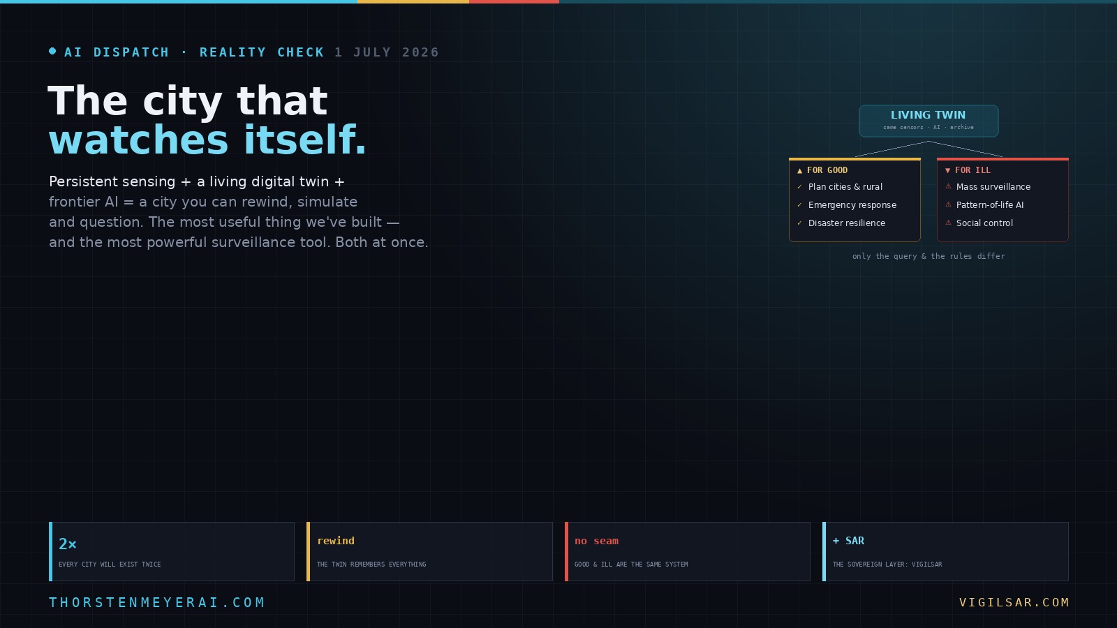
Soon most cities will exist twice — once in concrete, once as a live data model you can rewind, simulate, and question in plain language. Persistent sensing + frontier AI turn the planner’s digital twin into an oracle. The most useful thing we’ve built — and the most powerful surveillance instrument. Both at once.
- Plan better — cities & rural: traffic, zoning, energy, land use
- Emergency response — route crews, one live picture, ~50% faster
- Disaster resilience — simulate, track live, assess damage in hours
- Mass surveillance — track everyone, retroactively, forever
- Pattern-of-life — AI links movements, infers associations
- Social control — no warrant, no suspicion (cf. Baltimore, 2021 ruling)
We’re building a city that watches itself, remembers everything, and can be asked anything. The technology won’t choose between saving lives and ending privacy — we will, through the rules we write now, while the twin is still under construction and the defaults haven’t yet hardened into permanence. WAMI and the living twin open our lives to a view from the heavens that, from the dawn of civilization until a heartbeat ago, was reserved for gods and stars. The question is no longer whether we can see everything — it’s who gets to look, and who watches the watchers.
What a city digital twin actually is
Start with the tame version, because it’s already real. An urban digital twin is a dynamic, three-dimensional virtual replica of a city that integrates data from IoT sensors, satellite imagery, GIS and building models, traffic systems, and utility networks into one live environment. Unlike a CAD drawing or a static map, it reflects real-time conditions and runs predictive simulations — showing planners how a zoning change ripples through traffic, how a new water main shifts pressure across the grid, or how sea-level rise swallows a coastline over decades.
The flagship is Singapore’s Virtual Singapore — a national-scale twin, notably launched after severe flooding in 2012, that models every building, road, tree, and utility in three dimensions with live overlays, and is now being extended underground to map subsurface infrastructure. Helsinki, Las Vegas, and others run operational city twins today. One agency reported saving tens of millions simply by using the twin to plan roads more accurately. The framing researchers now use is telling: the twin is becoming a city’s “shared operational brain,” and it is shifting governance from reactive to anticipatory.
That’s the version that shows up in glossy smart-city brochures. Now add the two ingredients that change its nature.

Geodesign, Urban Digital Twins, and Futures
As an affiliate, we earn on qualifying purchases.
As an affiliate, we earn on qualifying purchases.
WAMI is what makes the twin live — and rewindable
A digital twin fed only by fixed sensors and periodic satellite passes is rich but coarse; it knows the city’s systems, not its motion. Wide-Area Motion Imagery changes that. As covered in the previous briefing, a WAMI sensor watches an entire city at once, tracks every vehicle and pedestrian moving in the open, and — crucially — archives all of it, so an analyst can scroll time backward and follow any mover to its origin.
Fuse that into the twin and the model stops being a snapshot. It becomes a continuously updated, time-scrubbable record of the city’s actual life — not just “there is traffic on this street,” but “this specific vehicle went from here to there to there, last Tuesday, and so did these two hundred others.” Layer in synthetic-aperture radar to see through the cloud, smoke, and darkness that blind optical sensors — the all-weather layer VigilSAR is built to provide — plus satellite imagery, utility telemetry, and LiDAR, and you have a multi-sensor twin that is genuinely complete: continuous where you can fly, all-weather where you can’t, and remembered in full.

youyeetoo Unitree L2, 4D 3D Lidar – 30 Meter 360° × 90° Omnidirectional Ultra-Wide Angle Scanning – Sampling Frequency 128000points/s, RJ45 UDP – Unitree L1 Upgarde
[Introduction] Unitree L2, New Version 4D 3D Lidar – 30 Meter – Sampling frequency 128000points/s
As an affiliate, we earn on qualifying purchases.
As an affiliate, we earn on qualifying purchases.
The AI leap is the hinge — and it’s why this is happening now
Here is the part most coverage misses. The missing ingredient was never sensors or storage; those existed for years. The missing ingredient was comprehension. A gigapixel city feed plus a city’s entire data exhaust is unreadable by humans, and until very recently it was unreadable by machines at the level required. You could record everything and understand almost none of it.
The current generation of frontier models — the capability jump we’ve been tracking in Fable 5 and GPT-5.6 — is what closes that gap. Models at this level can fuse wildly heterogeneous data, understand scenes rather than just detect pixels, recognize patterns of behavior over time, and, most consequentially, let an operator query the city in natural language. The interaction stops being “watch these screens” and becomes “show me every vehicle that visited these three addresses this month,” or “simulate a levee failure here and route the evacuation.” That is the leap from a dashboard to an oracle — a city you can interrogate.
It also inherits the vulnerability we’ve documented all month: that intelligence lives in frontier models a government can gate overnight, as Washington did to Fable 5. A city that rents its twin’s brain from a foreign lab has quietly made its most sensitive infrastructure hostage to someone else’s export policy — which is the first of several reasons sovereignty runs through this entire story.

SensorWorks® IoT Gateway Bundle | Includes Tektelic Kona Micro IoT Gateway + 1-Year Unlimited IoT Data Plan | Plug-and-Play LoRaWAN® Gateway for Smart Buildings & Facilities
🌐 Complete IoT Gateway Bundle – Includes the Tektelic Kona Micro Gateway, pre-activated SIM with 1-Year Unlimited LTE-M…
As an affiliate, we earn on qualifying purchases.
As an affiliate, we earn on qualifying purchases.
The good, part one: planning cities — and rural areas — better
Point this capability at planning and the payoff is real and large. On the twin, you test before you pour concrete: model a new transit line, a rezoning, a district’s energy use, the heat-island effect of a design, pedestrian flows through a plaza — and see the second-order consequences before they become expensive mistakes. Singapore’s own numbers point to shorter planning cycles, fewer overruns, and better land use.
And it isn’t only cities. Persistent sensing extends the twin to the places too vast to monitor on foot: farmland, forests, coastlines, and the long infrastructure corridors — pipelines, rail, transmission lines — that thread through rural regions. The same fused model supports precision agriculture, land-use and watershed planning, infrastructure inspection, and environmental monitoring across whole landscapes. For sparsely populated regions that have always been under-observed, a wide-area twin can mean better roads, earlier warning of erosion or drought stress, and infrastructure that gets fixed before it fails rather than after.

Tapo 2K Indoor/Outdoor Wired Security Camera – Works as a Baby Monitor & Pet Camera, Person/Motion/Baby Cry Detection, 2-Way Audio, Siren, Subscription-Free Local Storage or Optional Cloud, C113
𝐃𝐞𝐬𝐢𝐠𝐧𝐞𝐝 𝐟𝐨𝐫 𝐈𝐧𝐝𝐨𝐨𝐫𝐬 𝐚𝐧𝐝 𝐎𝐮𝐭𝐝𝐨𝐨𝐫𝐬 – Tapo C113's compact, IP65-rated design protects against heavy rain and dust for…
As an affiliate, we earn on qualifying purchases.
As an affiliate, we earn on qualifying purchases.
The good, part two: emergency response
A live twin is, for emergency services, a shared real-time picture of the kind Ukraine’s Delta system proved on the battlefield — only pointed at saving civilians. Dispatchers route ambulances and fire crews around live conditions; commanders watch an incident unfold from above and coordinate across agencies from one common view; the archive reconstructs exactly what happened for the after-action review. Mature deployments already report cutting emergency response times substantially by giving every responder the same synchronized picture instead of a dozen siloed ones.
The good, part three: natural disasters, before and after
This is where the technology is at its most unambiguously humane. Before a disaster, you rehearse it on the twin — simulate the flood, the wildfire, the quake; find where the water goes, which routes survive, which hospitals get cut off; harden the weak points and pre-plan the evacuation. During, persistent sensing tracks the event live: optical WAMI where the air is flyable, and radar where it isn’t — because you cannot fly an optical sensor through a hurricane or a wildfire’s smoke column, but SAR sees straight through both, day or night. That all-weather layer is the difference between watching a disaster blind and watching it clearly. After, change-detection against the archived twin turns damage assessment from weeks of windshield surveys into hours of automated comparison, speeding aid to where it’s actually needed. Wildfire mapping and post-hurricane infrastructure assessment are already documented WAMI use cases; the twin makes them systematic.
The peril: the same machine, turned on the people in it
Now hold everything you just read in your mind and change one word — from emergency to everyone.
The identical system that routes ambulances and models floods is, without altering a single sensor or line of code, the most complete surveillance apparatus ever conceived. A living, rewindable, queryable twin means persistent tracking of an entire population, retroactively, with an AI that can follow any individual across days, link their movements into a pattern of life, infer their associations from who they meet, and do it for everyone at once — no warrant, no suspicion, no forgetting. This is not speculative: the Baltimore Police Department secretly flew persistent aerial surveillance over the city in 2016, and a federal appeals court ruled in 2021 that continuously tracking a city’s movements this way violated the Fourth Amendment. That was crude, pre-AI WAMI. Fuse it into a full city twin and hand it a frontier model, and you have an instrument of social control whose logical endpoint is the integrated surveillance city already being exported by several states.
Vendors are not coy about this. “Real-time surveillance” and “monitoring public spaces” sit in the same product brochures as “flood modeling” and “traffic optimization,” because they are the same product.
Dual-use isn’t a bug — it’s the defining property
Here is the crux, and it deserves to be stated without hedging: there is no technical seam between the benevolent twin and the tyrannical one. The ambulance-routing model and the dissident-tracking model are the same fused, live, queryable city. Identical sensors, identical AI, identical archive. The only differences are the query someone types and the rules that govern who may type it. The capability is genuinely neutral; the use is anything but; and the guardrails are the entire distance between the two.
This is why “should we build it?” is the wrong question. Cities are already building it, the planning and disaster benefits are real, and the technology is diffusing regardless. The question that actually decides which society you end up living in is narrower and harder: who gets to look, at what, with what authority, and who watches them do it.
What decides which twin we get: governance, not technology
If the sensors and the AI are neutral, then everything rides on the rules built around them — and those rules are boringly concrete. Data minimization and hard retention limits, so the archive isn’t a permanent record of everyone forever. Warrant requirements and purpose limitation, so “find the flood victims” can’t quietly become “find the protesters.” Access controls and immutable audit logs, so every query has a name attached and someone reviewing it. Independent oversight with real teeth.
And running underneath all of it, the sovereignty question this series keeps returning to: who owns the sensors, the model, and the archive. A twin whose brain can be switched off by a foreign government, or whose data sits on infrastructure outside your law, is neither resilient nor accountable. Sovereign, auditable, on-premise control — the posture VigilSAR is built around — is not merely a procurement preference here; it is a civil-liberties safeguard, because accountability is impossible over a system you don’t actually control. The same technology under genuine democratic oversight and under an unaccountable state produces opposite societies. The hardware is identical. The outcome is not.
The take
We are building a city that watches itself, remembers everything, and can be asked anything. Used one way, it plans better places, shortens disasters, and gets the ambulance there faster. Used another, it ends privacy as every prior generation understood it. The technology will not choose between those futures. We will — through the rules we write now, while the twin is still under construction, rather than after it is finished and the defaults have hardened into permanence.
Because this is the deeper truth of the whole enterprise: WAMI and the living twin it feeds open our lives to a view from the heavens that, from the dawn of civilization until a heartbeat ago, was reserved for gods and stars. That vantage is no longer divine, and no longer distant. It runs on servers now, and someone owns them. The question is no longer whether we can see everything from above. It is who gets to look — and who watches the watchers.
Sources: on WAMI — BAE Systems, RUSI, Fraunhofer IOSB, and public reporting (see the prior ISR briefing); on urban digital twins — Virtual Singapore (Singapore Land Authority / OECD-OPSI), and 2026 analyses of city digital twins in planning, resilience, and disaster management (Helsinki, Las Vegas, SNEHI); on the AI capability leap — coverage of Fable 5 and GPT-5.6 (vendor and independent reporting, capability figures unverified); Baltimore aerial surveillance via Leaders of a Beautiful Struggle v. Baltimore Police Department (4th Cir., 2021). Analysis and framing are the author’s; the closing reflection paraphrases a theme explored in Arthur Holland Michel’s Eyes in the Sky. Related: VigilSAR — sovereign, all-weather SAR ISR.